There are many enhancements to ArcGIS for Desktop coming in 10.1 (opens PDF) and here are my top ten favourite features (in no particular order) using a scenario based on a long weekend in Edinburgh. For my basemap, I’m using the EsriUK Online OS MasterMap ‘Carto’ premium map service which we can see if we open the Service Credits icon bottom right of the map.
1. Support for GPS data
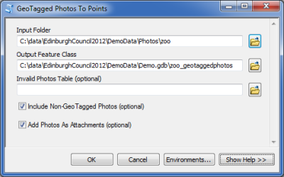
There are 85 new tools and 117 improved tools available in Toolbox and for my first enhancement I’d like to show you one of the new tools providing better support for working with GPS data.
You really can’t come to Edinburgh just now without making a trip to the zoo to see pandas Tian Tian and Wang Guang (Sweetie and Sunlight). Whilst visiting the pandas, I took some photos with my GPS enabled smartphone and I can use the new GeoTagged Photos to Points tool to create a new point layer showing the locations where I took them on my map.
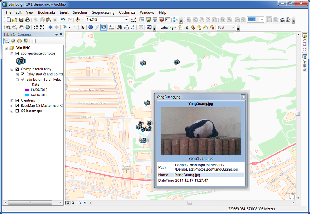
Obviously all the media attention has been too much for Wang Guang!
2. Editor Tracking
Editor tracking has been implemented within Geodatabases so you can now record information about who made changes to datasets and when the edits were performed using auto-populated fields.
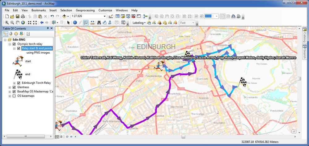
Here I can see that the routes of the two Olympic torch relay stages in Edinburgh on the 13th and 14th of June have been digitised so people can go and cheer the runners along their mile.
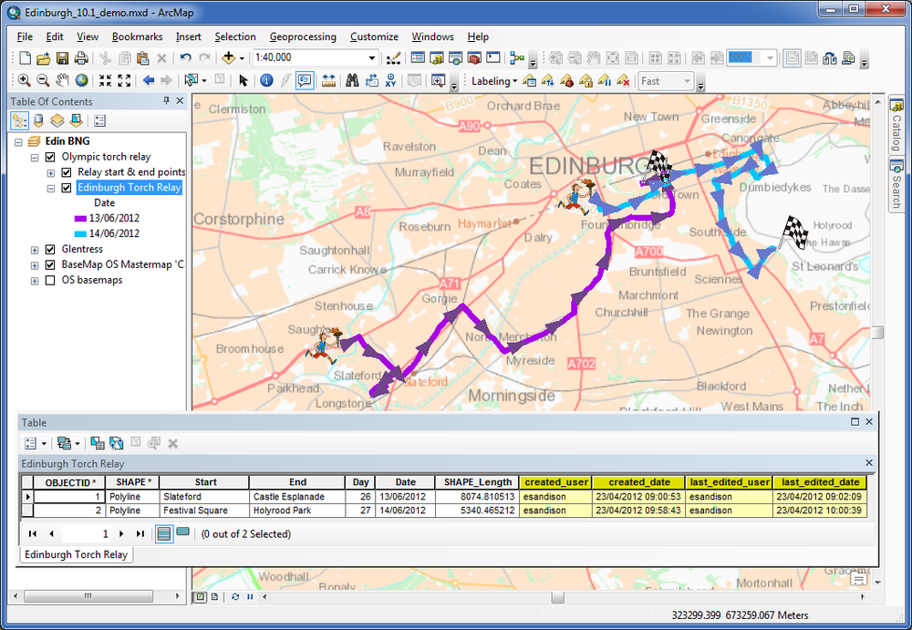
Through editor tracking, an editor’s username and time stamp are stored in attribute fields directly in the dataset (shown in the image above). This can help you enforce quality control standards, maintain responsibility and also create a log of changes that have happened on each dataset.
3. Symbol Support
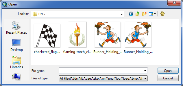
My third improvement is greater image support for symbols. As you can see, I have another layer displaying the start and end points of the relay routes using picture symbols. At 10.1 you can now use PNG and JPG images for your symbols.
4. Python Support
Python is now supported as a scripting language for all locations where scripting is used. You can program your own buttons and tools using Python add-ins and you can now create geoprocessing toolboxes entirely in Python.
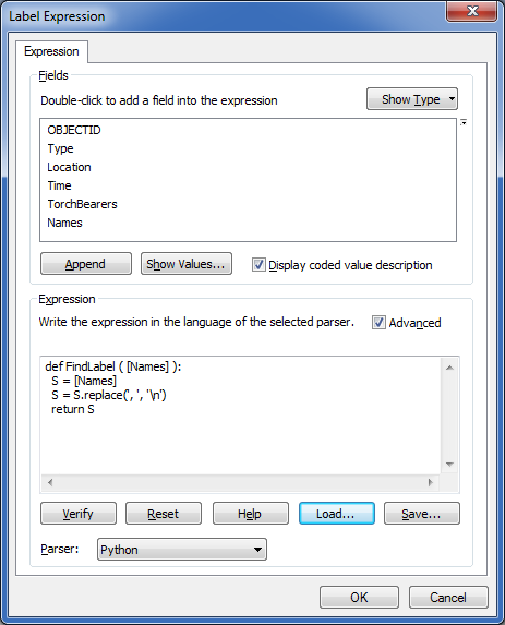
For example, with the new label expression parser, you can now use Python to add logic to your label expressions, including conditional logic and looping.
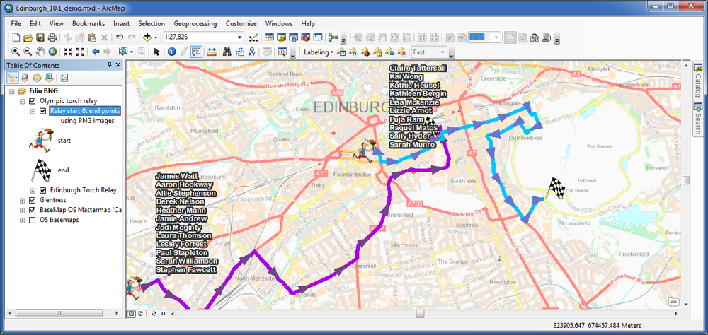
The screenshots below show a before and after using the label expression parser. The first image is showing the names of all the torch bearers running one mile of that leg of the relay but they aren’t displayed in a suitable format. This is clearly far too long to be an appropriate label!
A python expression that creates stacked labels, based on text from one field by using the comma between the torch bearers’ names to specify where the stack happens, makes the labels much easier to read.
So, for python users, we have far more flexibility in how we can label features without modifying the field contents.
5. Maplex Label Engine
The Maplex for ArcGIS extension functionality has been moved into the core Desktop and is now called the Maplex Label Engine. So it’s now available for everyone to use!
It provides a special set of tools that help you to improve the quality of the labels on your map, tools that were previously only used for specialist cartographic production.
I’ve heard that there is a great mountain biking centre just south of Edinburgh at Glentress so a day’s biking is on the agenda. The trails are colour coded by their level of difficulty – green, blue, red and black, just like for skiing.
As you can see from the screenshot below, important bends or trail features are shown with labels. The labels are currently using the standard label engine. By changing to using the Maplex Label Engine, they look much better, even before applying any of the label placement rules available.
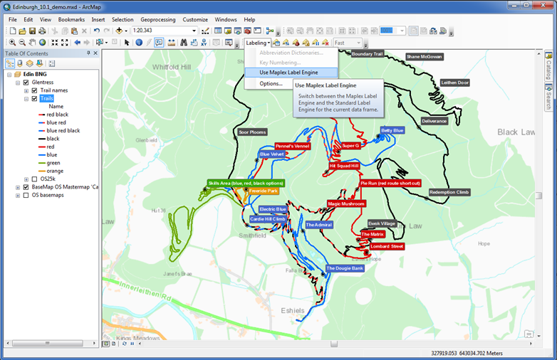
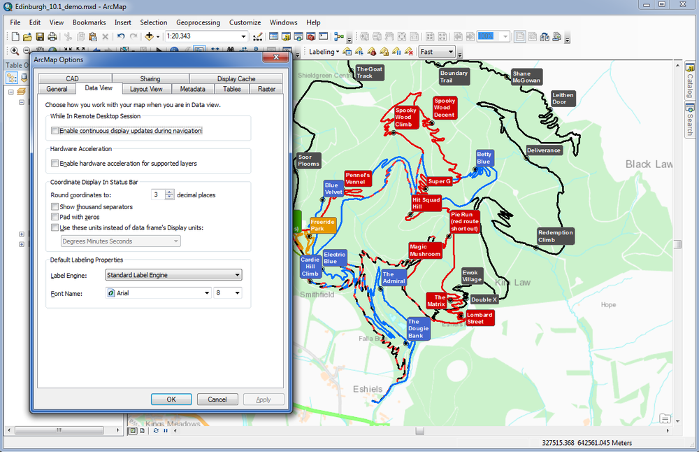
By default, new Map Documents (.mxd’s) open using the Standard Label Engine but you can change to Maplex and specify a different font name and size for labelling in Customise menu > ArcMap Options >data view tab, as shown in the screenshot above.
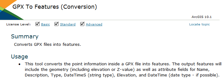
6. GPX to Features Tool
At number six is another tool providing better support for working with GPS data called GPX to Features. This converts the point information inside a GPX file into features, storing the geometry (including elevation or Z-value) as well as attribute fields for name, description, elevation etc. So this could be useful for all sorts of field data capture such as asset inventory or mapping the extent of a flood.
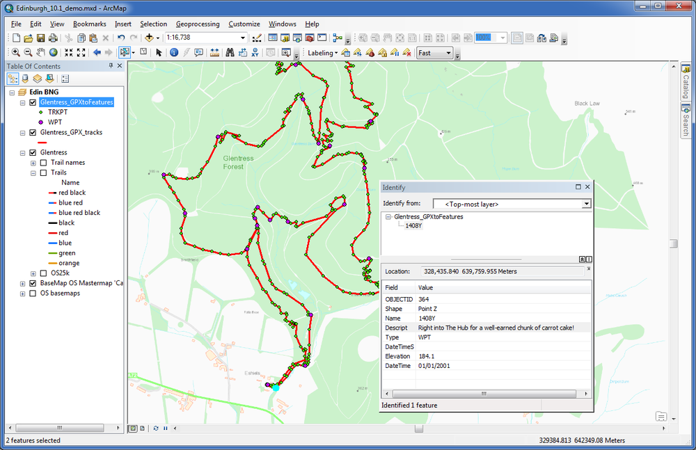
Whilst mountain biking at Glentress I’ve captured my bike route with my phone and can now use this new tool to add that to my map. Searching for the tool, we can see it’s a Python script that can be edited if you need it to do something different.
Help for tools have also been enhanced to show the licence level required (whether basic, standard or advanced).
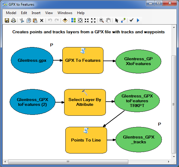
I’ve created a simple workflow using ModelBuilder to automate this conversion process and take it a bit further. This model creates the point features and then selects just the track points to create a linear track layer.
As you can see, we did the red route and because I have converted the waypoints and tracks, you can see that we stopped for some well-earned carrot cake at the end…showing that descriptive information can also be captured and converted along with the geometry.
7. Search Window
After the ride, I’d like to see where the showers and bike wash are. The new spatial filtering options can help me to narrow down my search for relevant facilities using map-based, text-based and scale-dependent searches and the results can be sorted and grouped.
With no spatial filter set, my search for ‘facilities’ finds both the Glentress and Innerleithen layer files. If I change it to ‘within or overlapping current extent’ it filters down to just the Glentress data.
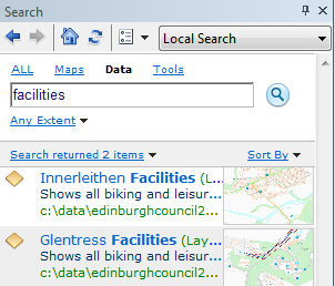
I can also view thumbnails and preview the result contents to check this layer is what I want. Each search result also has an enabled context menu enabling adding the layer and zoom to the layer’s extent.
8. Map Legends
I want to create a map in layout view to remind myself of the biking trip.
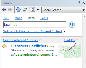
The new dynamic legends in 10.1 will be particularly useful for people using dynamic data pages and creating map books. They support the display of only features in the visible extent and the ability to show feature counts i.e. how many features of a certain kind are showing on my map.
The new Map Extent Options enable me to limit the features displayed in the legend to only those features currently visible on the map and also add feature counts. This works on an individual layer basis so can be set for only selected layers. I only want feature counts displayed for the facilities, not the trails.
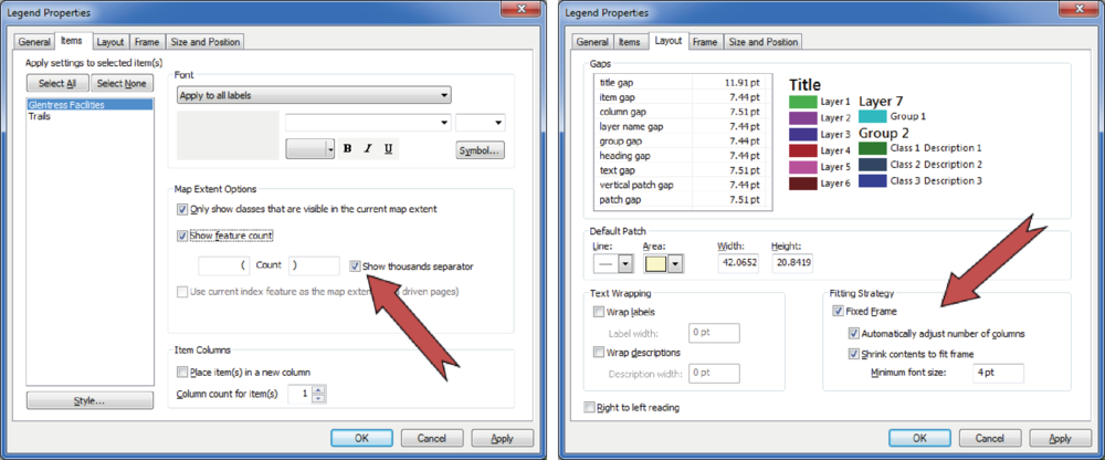
Fitting Strategy is also really useful if, like me, you’ve ever added a new layer to your map and the legend has shot off the top of the layout! You can fix the frame size so the items will change size to fit within the frame, rather than the other way around. Here are a few examples showing the dynamic legend and how the legend items fit into the available space when fixed frame is set.
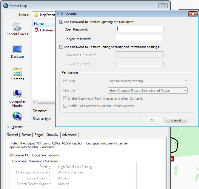
9. Password Protected PDFs
If I have sensitive information in the map that I want only certain people to see (maybe I took a sneaky shortcut) I can now set a password to limit access to it if I save it as a PDF. This was possible at 10 with python scripting but at 10.1 you can use the security tab in the PDF options of the Map Export dialog box to set a document-open password and other PDF security features.
10. Share As…
Lastly, I want to make my Glentress route map available to my biking friends and the new sharing tools make this really easy to do.
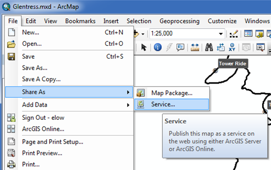
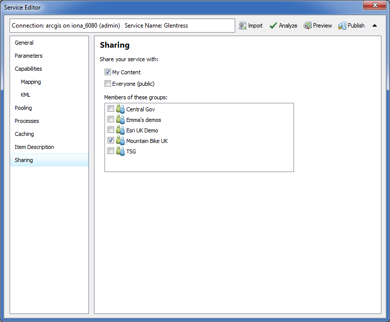
The wizard makes it very simple to take my map and publish it to both my server and ArcGIS Online.
In the service editor I can specify all the service properties. I can also choose to share my map with and of the groups I belong to. Then I just click Publish and it’s done.
So that concludes my top ten enhancements in ArcGIS for Desktop at 10.1 but of course we’ve only just scratched the surface. There are many more, including new analytical and geodatabase management tools, which you can read about here http://www.esriuk.com/products.